
Copyright © 2014 Bradshaw Geoscience Consultants Pty Ltd
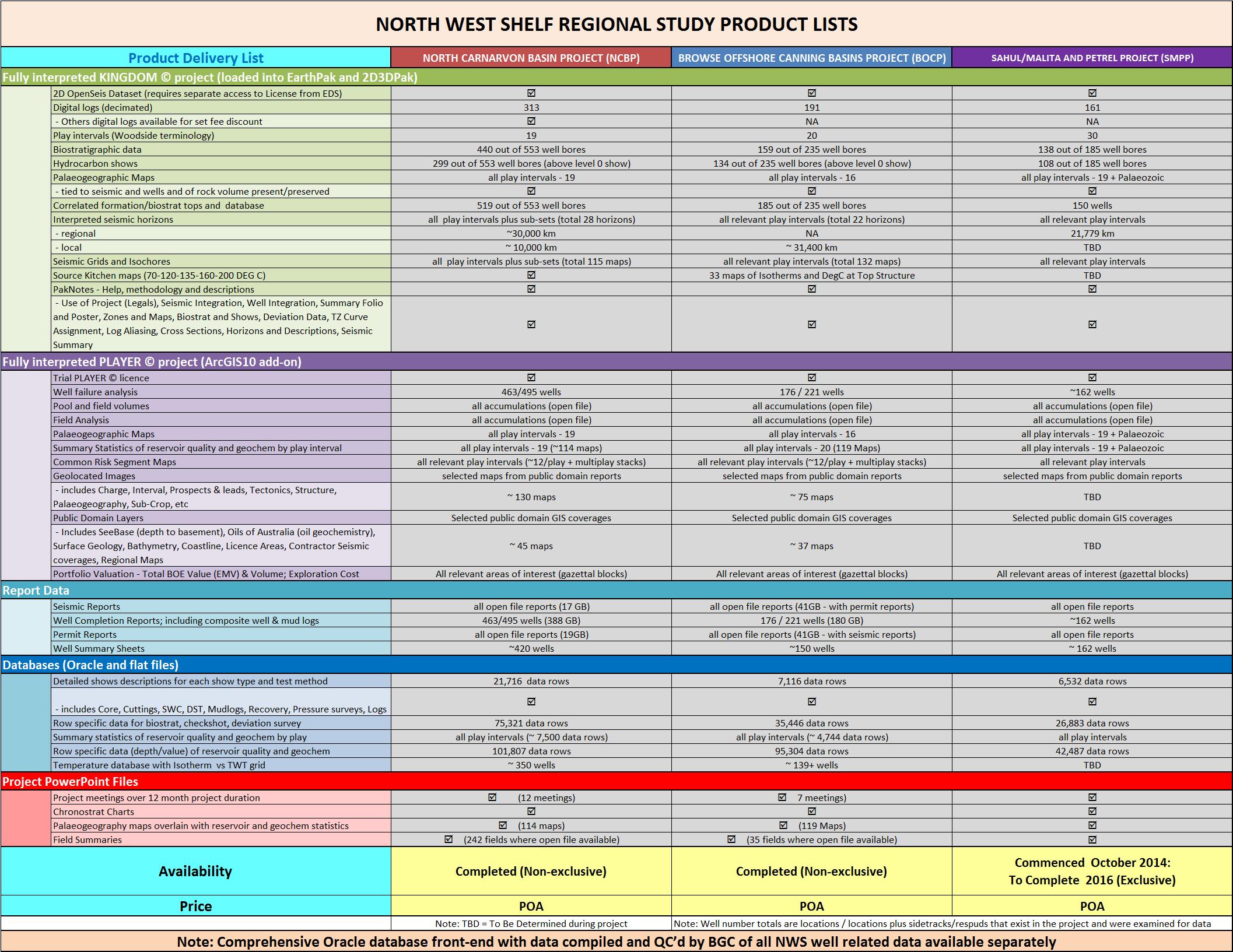
THE PLAYER NORTH CARNARVON BASIN MULTI-CLIENT FRAMEWORK STUDY
COMPLETED
THE PLAYER BROWSE & OFFSHORE CANNING BASINS MULTI-CLIENT FRAMEWORK STUDY
COMPLETED
THE PLAYER SAHUL/MALITA AND PETREL MULTI-CLIENT FRAMEWORK STUDY
UNDERWAY AND TO BE COMPLETED LATE 2015/EARLY 2016
COMPLETED
THE PLAYER BROWSE & OFFSHORE CANNING BASINS MULTI-CLIENT FRAMEWORK STUDY
COMPLETED
THE PLAYER SAHUL/MALITA AND PETREL MULTI-CLIENT FRAMEWORK STUDY
UNDERWAY AND TO BE COMPLETED LATE 2015/EARLY 2016
Products

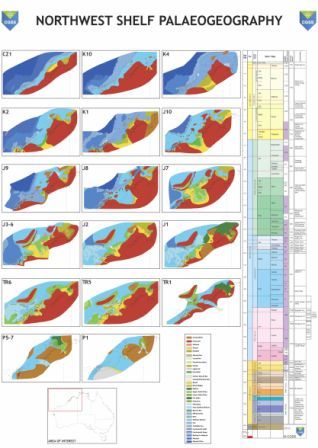
NORTH WEST SHELF PALAEOGEOGRAPHIC MAPS (ArcGIS 10)
17 NWS palaeogeographic maps from the early Permian to the Cainozoic as shape files in ArcGIS 10 format (including associated layers e.g. wells used in the palaeogeographic assessment).
For further information and pricing, please contact John Bradshaw.
17 NWS palaeogeographic maps from the early Permian to the Cainozoic as shape files in ArcGIS 10 format (including associated layers e.g. wells used in the palaeogeographic assessment).
For further information and pricing, please contact John Bradshaw.
BGC GEOSPATIAL DATA MANAGEMENT SYSTEM
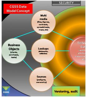
BGC and CGSS staff have been involved in the development and implementation of relational database systems since 1985; including constructing 17 separate corporate database systems for the resources industry. This knowledge and experience has led to development of the BGC Geospatial Database Management System (GDMS).
GDMS includes row level security; attribute-level sourcing with full auditing; and spatial functionality. Elements are located as points, lines or polygons with other attributes as applicable. These may include geological, chemical and physical properties, cultural features, and associated multimedia.
Currently the GDMS has all the available public domain well data (and BGC and CGSS compiled datasets) for every domain in Australia for data types such as reservoir (e.g. porosity, permeability), hydrocarbon shows, geochemistry (e.g. Rock-E-Val, TOC, VR, etc) depositional environments, etc. This data can be supplied as a functional database system, data dumps (as relational tables or spreadsheets) or as key maps or geological intervals with intelligent querying systems. These outputs can be linked in with the BGC spatial data (e.g. palaeogeography) for further detailed analyses of how to interpret the data.
BGC can also provide the interpretive skills to analyse this data for your area of interest. See for example The Player North Carnarvon Basin Multi-Client Framework Study and "The Player Browse & Offshore Canning Basins Multi-Client Framework Study".
Why you need a database
Before approving millions of dollars of expenditure for a company, executive management needs answers to questions such as: "How much do you want? What's in it for the company, and what's the return on investment?" The executive must balance answers with a myriad of other competing possibilities as to where to invest and when, and what are the likely ongoing commitments. Thus they must consider the investment portfolio over time against the life expectancy of the asset in which they have been requested to invest. And of course, will it save time and money, be efficient and increase productivity?
The resources industry is constantly changing due largely to the ongoing introduction of new technology in geoscience and IT. Occasionally, new technology does more than just upgrade existing procedures; it actually revolutionises how the industry operates and thinks. The emergence of Coal Seam Gas is a great example of that in Queensland, for which the existence of the resource was denied or ignored for decades, despite the data identifying its possibilities residing in the databases.
Information is the key to answering questions, and presentation and alignment of data is integral to the speed at which a solution can be provided. A strategy is available that can make the decision-making more productive. The solution is not new but its value has never really been properly understood. The key is the structure and discipline of how geoscience information is managed, both from a data viewpoint as well as its time and spatial context.
If you wish to know more about GDMS and the BGC data sets, or have BGC assist you with your data requirements or database solutions for the resource industry, then please contact John Bradshaw.
AUSTRALIA WIDE PALAEOGEOGRAPHIC MAPS (ArcGIS 10)
~70 Australia wide palaeogeographic maps from the Cambrian to the Cainozoic supplied as shape files in ArcGIS 10 format.
For further information and pricing, please contact John Bradshaw.
~70 Australia wide palaeogeographic maps from the Cambrian to the Cainozoic supplied as shape files in ArcGIS 10 format.
For further information and pricing, please contact John Bradshaw.

 format")

So what resource is hidden,
or lost,
in your corporate data system?
or lost,
in your corporate data system?
Bradshaw Geoscience Consultants
CO2 Geological Storage Solutions
CO2 Geological Storage Solutions


Note:
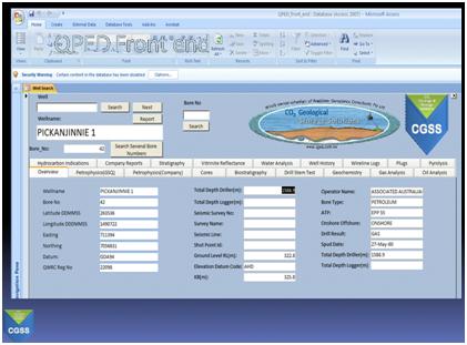
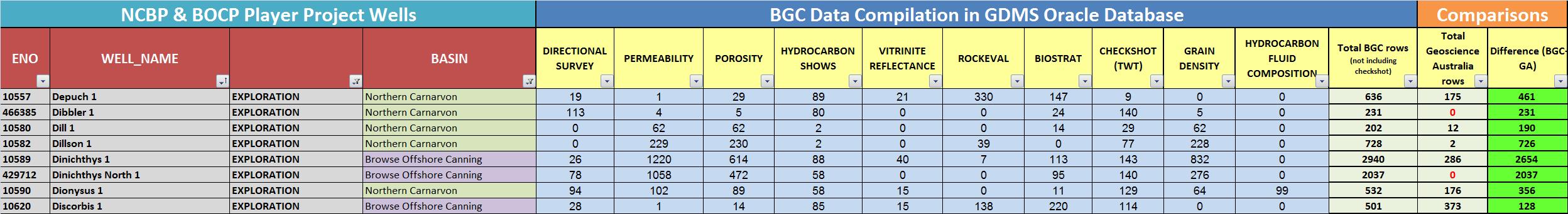
Upon request, BGC can supply a listing of rows of data per well per attribute type for the North West Shelf area of interest (see example shown below). Contact John Bradshaw.
To update your databases, talk with BGC for both quality and completeness of your information.
Upon request, BGC can supply a listing of rows of data per well per attribute type for the North West Shelf area of interest (see example shown below). Contact John Bradshaw.
To update your databases, talk with BGC for both quality and completeness of your information.
1.
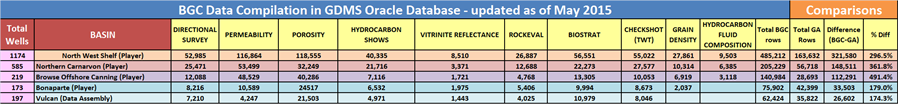
BGC continues to update and populate the data as it becomes open file and so the rows shown are only correct as of May 2015.
2.
The government checkshot data rows are not compared to above because of the large number of inaccurate and unreliable rows of data that exist with the information that government databases provide. For checkshot data, BGC has recompiled all the data from the well completion report data, rather than attempt to correct the many discrepancies that are in the government datasets.
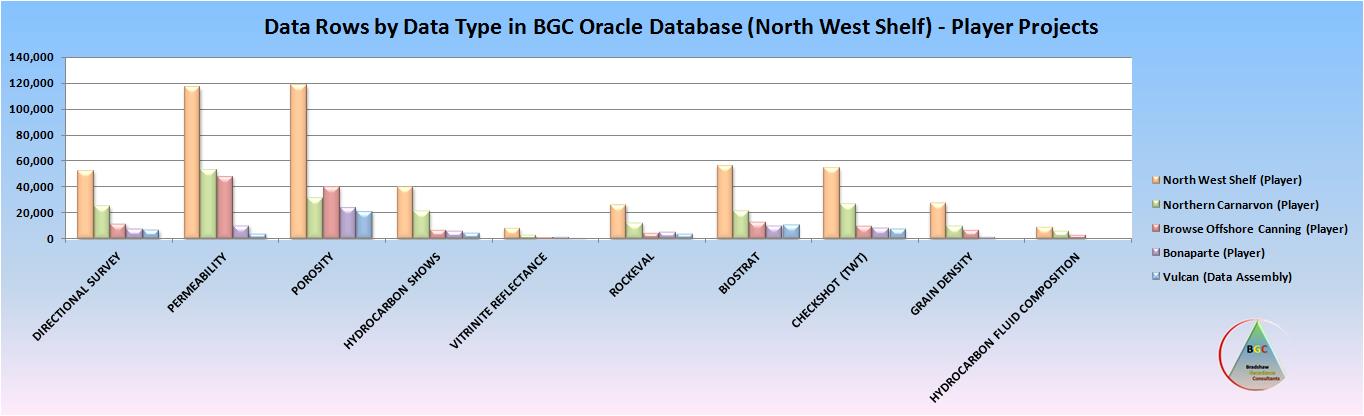
North West Shelf Database
BGC owns and manages the most complete petroleum well database (GDMS) that is either commercially or publicly available for the North West Shelf region in Australia. It has updated, corrected, recompiled and added to the public well databases that governments had traditionally provided, but which over the last decade governments have failed to maintain in a reliable or comprehensive manner.
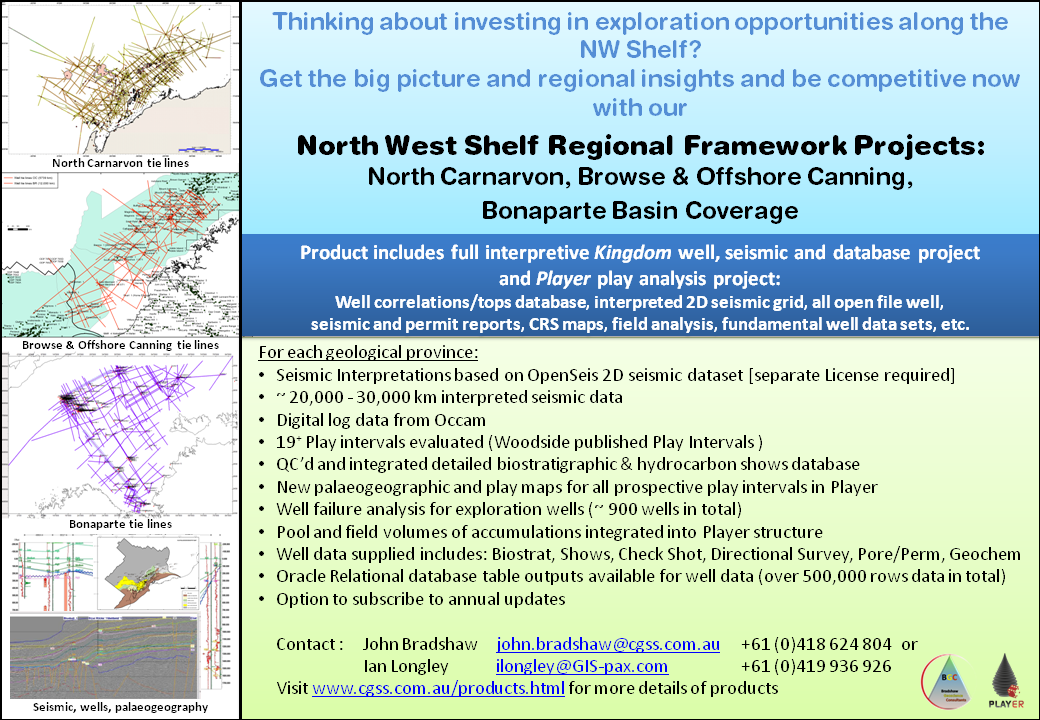
To overcome the significant shortfalls and errors in the online public government data sets, BGC has recompiled and updated the essential well data information for data types including biostratigraphy, permeability, porosity, hydrocarbon shows, vitrinite reflectance, rock-eval, directional surveys, checkshot and hydrocarbon fluid compositions. In doing this work, BGC has accessed not just the well completion report data (WCR), but also all the thousands of post well drilling reports from the core and cuttings warehouses across Australia.
In so doing BGC is able to provide a clean and comprehensive data set that can be relied upon to be correct and complete. These databases have been populated as part of BGCs role in developing the Player petroleum prospectivity packages. They now replace the government datasets as the only commercially available structured datasets that can be relied upon for correct and accurate data that is comprehensive on the North West Shelf. For the NCBP, BOCP, SMPP and VSB areas of interest, the following comparison exists (as at May 2015) between the government and BGC databases in terms of well numbers and total rows of data.
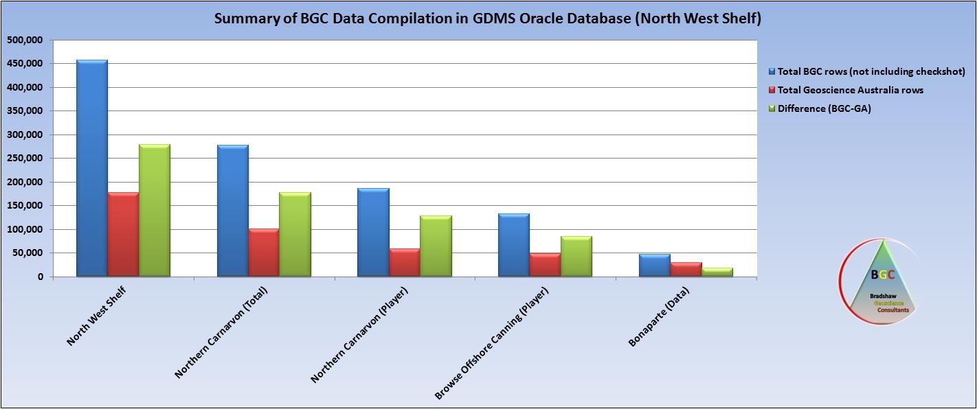
Shown below is the current (May 2015) data rows compilations done by BGC for the North West Shelf, and comparisons to Geoscience Australia public domain data rows.
BGC owns and manages the most complete petroleum well database (GDMS) that is either commercially or publicly available for the North West Shelf region in Australia. It has updated, corrected, recompiled and added to the public well databases that governments had traditionally provided, but which over the last decade governments have failed to maintain in a reliable or comprehensive manner.
To overcome the significant shortfalls and errors in the online public government data sets, BGC has recompiled and updated the essential well data information for data types including biostratigraphy, permeability, porosity, hydrocarbon shows, vitrinite reflectance, rock-eval, directional surveys, checkshot and hydrocarbon fluid compositions. In doing this work, BGC has accessed not just the well completion report data (WCR), but also all the thousands of post well drilling reports from the core and cuttings warehouses across Australia.
In so doing BGC is able to provide a clean and comprehensive data set that can be relied upon to be correct and complete. These databases have been populated as part of BGCs role in developing the Player petroleum prospectivity packages. They now replace the government datasets as the only commercially available structured datasets that can be relied upon for correct and accurate data that is comprehensive on the North West Shelf. For the NCBP, BOCP, SMPP and VSB areas of interest, the following comparison exists (as at May 2015) between the government and BGC databases in terms of well numbers and total rows of data.
Shown below is the current (May 2015) data rows compilations done by BGC for the North West Shelf, and comparisons to Geoscience Australia public domain data rows.
Example showing rows of data per well per attribute type. Click here to view pdf of example
North West Shelf Hydrocarbon Fluids Composition Database
BGC has constructed a database of hydrocarbon fluids composition (HFC) analysis for the North West Shelf.
The areas completed are the Northern Carnarvon Basin (NCB) and the Browse and Offshore Canning Basin (BOCB). This database has assembled the basic fluid composition analysis data for every exploration well for compositional analyses from C1 to C6 plus and includes the inerts such as CO2, N2, and H2S.
The analysis has come from samples recovered to the surface of hydrocarbons from formation testing (DST, PT, RFT, MDT, etc). Every sample has a reference source with the analytical operator report name and the digital page in the WCR of the report/sample. BGC has linked the depth intervals to our depth/age data set and extracted the age of each sample depth (millions of years) and the play interval (Woodside Schema) that the sample represents. A range of standardised algorithms have been calculated for each sample for aspects such as Wetness, Fluid Character, Density, and various ratios.
In the Northern Carnarvon Basin, 555 exploration wells were screened for HFC data resulting in over 6300 rows of data representing ~ 900 samples from 174 wells with formation tests. For the Browse and Offshore Canning Basins, 218 wells were screened for HFC data, resulting in over 3000 rows of data representing ~280 samples from 53 wells with formation tests.
The HFC database can be supplied in Oracle tables, flat file format, and as an ArcGIS project with ratios and fluid characteristics mapped. Contact BGC if you wish to purchase the HFC database.

Click here to view a pdf version of the above example
Click here to view pdf of the above example
Click here to view pdf of the above
One of the benefits of the BGC databases, is that the data has been exported to and used extensively in our North West Shelf multiclient prospectivity projects, thereby identifying and correcting any anomalies or deficiencies prior to release of data to clients.